These beautiful vistas await – without the biting bugs and pesky poison ivy.
The weather is changing and the leaves are about to turn, too. Fall is almost here, and to me, that means the most wonderful part of the year for hiking. I love fall – crisp morning air, cool nights, dying poison ivy, disappearing biting insects, and vibrant foliage displays. To get a bird’s-eye view of the changing season, I like to get up high on Columbia’s scenic viewpoints.
Smack dab in the middle of town is Capen Park. After a climb along smooth rocks, the view atop Capen cliffs extends miles across Grindstone Nature Area and Waters-Moss Memorial Wildlife Area. After seeing the view, take a walk along over seven miles of trails in Grindstone Park. All of the trails, except Hinkson Creek Trail, allow your well-behaved pooch to go leash-free.
Meet Ginger Schweikert, COMO hiker and author
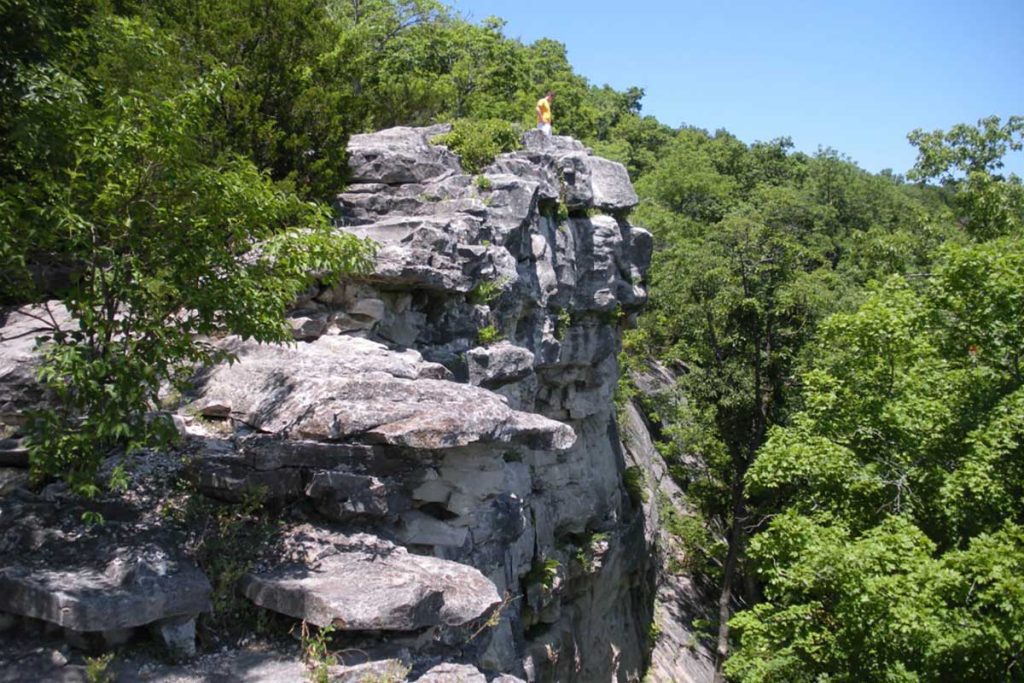
The star of Columbia’s viewpoints is the Pinnacles Youth Park, north on Highway 63 about 13 miles. It is a must-see. The limestone ridge, known as the Pinnacles, is 75 feet high and was formed as two parallel creeks, Kelley Branch and Silver Fork Creek, eroded the rock into a narrow strip. This trail is not for those afflicted with acrophobia as the drop-offs are steep. Those seeking a thrill can find nooks and windows that look down upon the creek below. A two-mile walking loop encircles the property, or you can go straight to the prize in less than half a mile.
The Missouri River is only minutes away from Columbia and along the river are blufftops that have views for miles. Diana Bend Conservation Area is just outside Rocheport along the Katy Trail. Hike along the Katy Trail west out of Rocheport and enter Diana Bend Conservation Area just before the tunnel. Follow the path up the hillside to a grand overlook of the wetlands below and the river beyond.
A bit farther south along the Missouri River is Eagle Bluffs Conservation Area. Eagle Bluffs Overlook Trail can be reached from the Katy Trail 2.9 miles southeast of the McBaine Trailhead or along Warren School Road. From the Katy Trail, you will ascend 160 wooden steps over 200 feet above the trail. From Warren School Road, the path is mostly flat for a mile to the overlook. The platform looks out across the Eagle Bluffs Conservation Area wetlands with regular sightings of its namesake birds.
Another grand viewpoint over the Missouri River is in Hart Creek Conservation Area. Located a mile outside historic Hartsburg, you have to work to get to this viewpoint. From the trailhead, the path is a gradual climb over 1.65 miles to the platform. Another option is to come from the Katy Trail, which is still 0.75 miles and much steeper – plus it’s nearly two miles on the Katy Trail from Hartsburg. Either way you go, you are likely not to see many other folks because this is off the beaten path.
Personally, I recommend doing a five-mile loop if you are on your bike or an out-and-back on the main trail if you are walking. Once at the viewing platform, you can see across the floodplain farmland to the mighty flow of the Big Muddy. You can hear the train horn from across the river and watch the boats go up and down the water.
Go even farther south to Painted Rock Conservation Area for gorgeous views over the Osage River on the Osage Bluffs Scenic Trail. The 1.8-mile trail is worth every mile of the nearly-hour commute to get there. Along the path is an Indian burial mound. The section along the 140-foot- high bluffs looks out along farmland, the Osage River, and Bloody Island. Read the interpretive displays along the way for some interesting history of the area.
If going north suits your fancy, check out Mark Twain State Park. The park offers camping, boating, and over five miles of trails. Most of the trails hug the shoreline and look at the water from above. A grand overlook provides views over the water for miles. From this vantage, you can see the boats below, the waves crashing, the water swirling, and the trees blowing. From Columbia, it is just over an hour away. Spend a day or a weekend and find some serenity.
Regardless of where you get your views this autumn, I hope you enjoy the trail along the way.
Find extended trail descriptions, maps, directions, and much more in my book Columbia Trails: Over 300 miles of Hiking, Biking, and Horsing Around in Mid-Missouri. Buy it locally at Walt’s Bike Shop, Tryathletics, Yellow Dog Bookshop, Cyclex, and Alpine Shop. Come find me at Zipperfest September or Mid-Missouri Pride Festival September 23-24 for a signed copy and a free sticker. Amazon will also deliver it to your mailbox.
See you on the trail!
MORE FROM “HIKING WITH GINGER“
COMO has ample hiking options for all skill levels
Overnightin’: Where to find camping close to COMO
Ready to go? Bring on the bikes