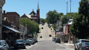
Early in its history, the Flat Branch area was Columbia’s primary commercial zone. Over time, it became a bustling industrial area with train traffic. But after the MKT rail line shut down, the historic creek bottom became dilapidated, and city leaders presented several plans to upgrade the area.
Proposals for a convention center, mid-city urban renewal, a civic center and a hotel complex all failed. In 1980, after the public shot down the civic center idea, drawn up by Annapolis, Md., consultant Don Zuchelli and promoted by community leaders, the city decided it had to catch its breath and try a different approach.
While Flat Branch is now a nearly completed city park at the beginning of the popular MKT Trail, its slow transformation had to overcome strong opposition from landowners.
As I learned throughout my career with the city, timing is important. Ideas and plans abound. The bottom line is what you can actually accomplish at a given point or over a period of time for some projects. You have to be patient and gradually implement a vision and plan that can be flexible while meeting an overall goal. Some projects and programs can best be “phased-in,” and some begin as “pilot projects.”
The Columbia City Council directed city staff to proceed in clearing up dilapidated housing in the area without using federal money. So we cleared the slum housing, and we started to work in partnership with other agencies, the university, property owners and businesses in the area to make improvements.
We looked at the needed roadway improvements, parking, use of city property, upgrades to the open Flat Branch Creek and MKT Trailhead, and a vision for redevelopment in the southwest corridor of downtown.
Sometimes change takes decades. For instance, we have known for nearly 30 years that the intersection at Providence Road and Broadway, on the periphery of the Flat Branch area, needed an upgrade with free right-turn lanes to improve traffic flow and pedestrian crossings. A plan was prepared and then gradually implemented for separate right-turn lanes, pedestrian closings and landscaping. Today, three lanes have been completed for this landscaped intersection — a window from the west to downtown Columbia.
As land became available, the city purchased it to implement the separate right-turn lanes. I recall negotiating land on the southeast corner of the intersection from Gladys Roth. Part of that land was used for the right-turn lane, part was landscaped, and part became a paved city parking lot between Providence Road and what was then the ice plant.
In the 1990s, we purchased the land where Streetside Records had once been located, on the northeast corner next to the MFA service station, which has been abandoned. We can thank Dan Hagan, who agreed to sell us property below market value and provided $5,000 in landscaping for the project. When the city learned that Walgreen’s planned to locate on the corner, we negotiated for land to complete the southwest corner. Without considering eminent domain, I’m not sure when the northwest corner will be completed.
We reconstructed 4th Street from Broadway to Cherry Street, making it much narrower than it had been in its railroad heyday. The section south of Cherry Street was left “blacktopped” southward to Locust Street where metered parking is available to support local business and the city park.
We had to decide whether to extend 4th Street south from Locust Street to Elm Street. While it is often desirable to have a circulation street next to a major thoroughfare such as Providence, we decided to let it remain a temporary parking lot until plans for a parking garage and extension of the park southward to Elm were determined.
The Elm Street expressway from Broadway just west of Providence to College Avenue, envisioned in the Zuchelli plan, died in the 1980 vote, but we still needed Elm extended to Providence. Luckily, when the city built a new public works operation center, the Grissum Building, it allowed the city to abandon the large Quonset hut used for refuse operations and street department storage on land south of Elm, between Flat Branch and the university power plant. The city no longer needed the land, and the university could use it.
In 1983, I recall beginning negotiations with the university for the trade of land and the extension of Elm Street. The goal was to trade city-owned land south of what is now Elm Street for Elm Street right of way and land along Providence to house Columbia’s Convention and Visitors Bureau (CVB) and Chamber of Commerce.
The cost of constructing Elm Street would be shared. The university would purchase land along Providence Road south of Hardee’s to trade with the city. This land was being considered for private development, making it important to move forward in a timely fashion. After months of staff discussion by both parties, I recall contacting Duane Stucky, vice chancellor for administration, and the two of us met to work out an agreement that was presented to the City Council and the Board of Curators of the University of Missouri and was approved in 1985. Maps, land appraisals and street costs were used to help ensure a fair agreement.
Our city should be proud of its long-standing tradition of a good working relationship between local government and the university, which is different from that in many other college towns. The construction of Elm Street allowed better access to the expanding power plant, a new Convention and Visitors Bureau project (the Walton Building) at the northeast corner of the Providence/Elm Street intersection and a feeder street for both the north campus area and the south-central business district. The Chamber of Commerce reimbursed the city for half of the land and building cost. The CVB, Chamber of Commerce and Regional Economic Development Inc. (REDI) occupied offices at this location before REDI’s recent move for space reasons.
The issue of whether and how to develop the MKT Trail also came into play during the time I was acting city manager and later on as city manager. We tend to look at the trail as an asset now, but opposition to it was strong from landowners abutting the railroad and, especially, from council constituents in northern Columbia.
A lot of planning went toward the MKT Trail. Richard Green, Parks and Recreation director, and his planner, Steve Saitta, City Counselor Scott Snider and I spent substantial time with federal agencies asking for grant funds and discussing land rights issues. Under a relatively new law, legal opinions indicated the city could build a trail on railroad right of way without purchasing additional land rights.
Just prior to the council meeting and hearing, some council members visited my office to tell me the majority of the council would vote against a trail because of the strong opposition both in and outside of the city and because it could not be a city priority. I recall quickly explaining that we could phase in the project as community acceptance grew and I recommended purchasing any property rights to be fair to the owners. We could start phase one where the city and university owned most of the adjacent land.
This was the only “courtesy visit” of this nature that I can recall as city manager for more than 20 years. Following the hearing, my staff report suggested that we phase in the overall project and buy out property rights that might yet remain. Phase 1 was from Stadium Boulevard to Scott Boulevard, where the city and university owned most adjacent land; phase 2 ran from Stadium to Providence/Stewart; phase 3 will run from Providence/Stewart to Flat Branch Trailhead Park; and phase 4 will go from Scott Boulevard to the state MKT Trail near the Missouri River. Phases 1 and 2 were constructed to Stewart Road. Years later, after a 4-to-3 vote of the City Council, phase 3 with the Flat Branch Trailhead was under way.
The university provided an easement on the eastside of Providence and Pon and Kimi Chinn drew up plans for about a half-acre park, which grew much larger as planning continued. Dedicated in 2001, the park became an important center for recreation, outdoor movies and other events.
Land for the part between Fourth Street and Providence Road was purchased from several landowners using Community Development Block Grant funds and other sources. I remember negotiating for the land owned by Helen and George Crawford over Helen’s dining room table — perhaps that’s how Flat Branch Park got its start. Later, as the park expanded southward to Elm Street for the potential connection to Peace Park and the university gardens, the city fortunately already owned and kept most of that property.
Slowly, things were shaping up in the Flat Branch area, thanks to $200,000 in federal funds and $1 million in state funds for cleanup. The area’s industrial past led to a series of environmental cleanups of such items as underground oil tanks in 1991 and contaminated soil in 2001 and 2003. We also had to convince a local concrete company to quit dumping concrete leftovers from various construction jobs onto the bank of the creek. They said it helped to stabilize the creek bank. Although concrete is stable, it isn’t very pretty.
Meanwhile, area businesses had already been making small changes for the better. Hardee’s opened in 1978 and was rebuilt after burning down in 2001. In 1982, Mark Stevenson purchased the old ice plant from Clyde Cunningham, economics professor and city councilman, who had in turn purchased it from L.A. Nickel years before. Stevenson rehabbed the building and changed it into offices and stores.
In the 1990s, many old buildings in the area were torn down and some replaced by newer construction, such as the Tiger Meatpacking building at Fifth and Cherry, and the Atkins store. Other owners, such as the Callahan & Galloway property management firm and Tim Brockmeier, chose to rehabilitate old houses. A new office building was constructed at Fourth and Elm, and the large structure at the southwest corner of Fifth and Cherry was rehabbed. Flat Branch Pub and Brewery opened in 1994 in a 1927 warehouse that once held a Hudson dealership.
Katy Station restaurant, which is now the Coliseum Bistro, opened in the old depot in 1976. After it closed in 1998, the city considered purchasing the depot building, which had been built in 1901, for the Convention and Visitors Bureau, but we decided that the Walton Building was the preferred location to house the CVB, Chamber of Commerce and Regional Economic Development Inc., because of the related missions of those organizations.
In 1982, attorney Edgar Wayland helped the Columbia’s Muslim community build the Islamic Center of Central Missouri at Fifth and Locust streets, which was an interesting proposition because the building had to be aligned carefully in accord with Islam’s tenets. A year later, the Islamic Center sought to build a nearby housing complex as well. However, in 1998, the city council turned down the center’s request to construct a cultural center on the land that was under discussion for use as the trailhead park.
Because it did not appear that a large department store would ever be built to help anchor the downtown area, I discussed in the mid-1980s with Mayor Mary Ann McCollum and the council a vision for redevelopment in the southwest corridor of downtown, also known as the Flat Branch area. As reported with a picture at that time in the Columbia Daily Tribune, the council visited the area during a public work session to discuss a possible city role. Part of the goal was to provide local attractions and bring tourists downtown and to the university.
The city purchased the remaining land it did not own in the block bounded by Fifth, Sixth, Cherry, and Locust streets, converting surface parking to a parking garage with surplus space on the west side available for future development. We contacted Ann Cowan, chair of the Health Adventure Center Board (now the YouZeum), and the board revised its planning for a downtown site. The YouZeum’s initial plan was to use the land west of the garage, but changed to the Federal Building when it became available. When the Blind Boone home became available, the city purchased it to preserve its historic significance to the area and to develop it in the future as another attraction. Proposals to move the Art and Archeology Museum and State Historical Society have not materialized to date.
In 1997, Mayor Darwin Hindman appointed a 22-member committee to design the Flat Branch trailhead park. John Ott chaired the committee, and Jack Waters played a major role. Other members of the committee included Almeta Crayton, Bill Crockett, Blake Danuser, Brad Eiffert, Bill Farrand, Tom Flood, Jim Goodrich, Verna Harris-Laboy, Raymond Linzie, Mary Anne McCullum, Paul Mehrle, Fran Pope, Nick Peckham, Tom Prater, Benjamin Schwarz, Tom Smith, Don Stamper, Jim Whitley, Betty Wilson and Dick Wolken. The net cost of the Flat Branch plan after all of the federal grants and dozens of private donations is estimated to come to about $900,000. Parks and Recreation Director Mike Hood and his staff have done a great job in designing and managing the Flat Branch Park development. Mayor Hindman and the City Council have continued over the years to be supportive of the redevelopment of the Flat Branch area.
Prior to the development of the park, the land across the creek from the Walton Building was used for overflow parking, but much of that land would later be used to enlarge the park. A bridge over Flat Branch, which was donated by Ron and Vicky Shy at a substantial cost saving to the park project, connects a small overflow parking lot for the Walton Building.
The revitalization of the Flat Branch area was an example of slow development over time. The city has been following a vision and plan while remaining flexible. Different from some downtown areas, the parking garage has been acting as an anchor for supporting redevelopment in the area. The garage provides primary parking and overflow parking for many of the current new and rehabbed structures in the area. It is designed so that an additional floor may be added in the future, if needed.
With the great Flat Branch Park being completed, the potential for additional museum, historical and educational attractions, in this once-dilapidated part of our downtown area can once again be a major attraction and gathering place for our community.