Mitigating Rush Hour

Congested scenes on South Providence Road during the weekday afternoon rush hour are found on many of Columbia’s points of access. You’ll find jams on portions of East and West Broadway, Stadium and Forum boulevards. Equally problematic is the College Avenue/Business Loop 70/Range Line Road left turn/right turn jog with long lines and poorly synchronized traffic lights to frustrate anyone quitting Columbia to head north.
College Avenue could have been a lot worse. Sixty years ago when Columbia was a city of 32,000, College Avenue was a short two-lane street that ran south from East Broadway along the east edge of the University of Missouri campus, down a hill past the old Fellows Quarry and “The Hink,” across the creek on an single-lane iron bridge that’s still there and out into the country as a dusty gravel road. Going north the opposite direction from East Broadway with a jog past three gas stations and Lela Raney Wood Hall, the avenue was christened Tandy and terminated in a maze of streets that included Hinkson and Price avenues.
Poor planning, unexpected growth
Although College Avenue was improved with its extension to the Business Loop, a huge opportunity to move outbound traffic was forfeited at the time. The trace of the projected four-lane divided pavement Highway 40 bypass — Interstate 70 from 1956 — first appeared on city maps more than 60 years ago, and with it came golden opportunities to develop interchanges with nearby city streets. Poor planning and the failure to anticipate Columbia’s rather dramatic growth left us with no I-70 connection at Route B (quaintly called Mexico Gravel Road at the time), the missed opportunity to extend College Avenue and integrate it with the present Range Line/Interstate 70 interchange and the poorly engineered interchange with West Boulevard and Creasy Springs Road and the recently added traffic circle.
Shame on our lazy, inattentive past. Columbia’s city fathers never thought Collegetown, U.S.A., would grow and expand as it did by leaping southward across the Great Hinkson Creek Valley with new suburbs and only five bridges to ford the beloved creek or the northward march across the Bear Creek Valley where growth and development came somewhat later. A particularly glaring omission of planning is that it took decades before Providence Road was extended north of Vandiver Drive to leap across Bear Creek.
Connecting the loops
Fortuitously, there was some highway planning and construction inside the city limits starting in the 1950s thanks to the then-named Missouri Highway Commission, which provided Columbia with two loops. The Outer Loop (Highway 740), completed in 1963, now Stadium Boulevard, was initially a two-lane bypass that ran from Interstate 70 to Providence Road. Later eastward extensions — subsequently widened — brought Stadium to College Avenue, then Old 63 South and finally in the late 1970s to New Highway 63. Still under consideration is the final leg of Stadium Boulevard; we hope it’s to the Interstate 70/Route Z interchange because it makes sense to connect with the area around the new Battle High School rather than the more problematic, though closer, Lake of the Woods interchange.
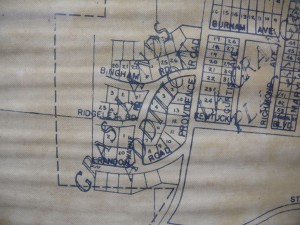
The Inner Loop, now Providence Road, was a project tied to urban renewal that widened Third Street southward from Interstate 70 and Business Loop 70 through the city center before cutting a new path to join a two-lane street called Providence Road that was really an extension of South Fifth Street. With the Grasslands subdivision as its eastern boundary, Providence Road crossed the Outer Loop (Stadium Boulevard) before heading out into the country as Route K toward its namesake village and Columbia’s once-upon-a-time port city on the Missouri River. Subsequently widened with a center turn lane, Providence Road has become an unadulterated rush hour mess while efforts to fix its deficiencies seem to have been rather ham-handled so far.
Retire the MoDOT bat
Recalling one MoDOT staffer’s rather caustic admonition to a developer that “we [MoDOT] have the ball, the bat and the glove,” our confidence in this normally laudable state agency is being tested as it seeks to resolve issues of congestion at the Stadium/Providence intersection. MoDOT, it seems, with the concurrence of the Columbia City Council has gone overboard. A more modest solution would add a right turn lane onto Stadium from Providence extending northward and sacrificing a half dozen or so houses is no particular architectural merit. A tall berm slathered in plantings goes up to form the eastern extremity of the subdivision while the proposed though controversial interior street is rejected thus saving the city $3 million that would be better used elsewhere.
The debate is ongoing, but then so is the growth of the city.
Time out!
Retire the MoDOT “bat,” and let’s send everyone back to the dugout for further consideration.


