Now Reading
Transportation changes key to Columbia’s population growth | From the Roundtable

Transportation changes key to Columbia’s population growth | From the Roundtable

It’s official: 108,500. That’s the number of people who were living in Columbia in April last year when Census Bureau workers canvassed the city. Wow. That’s a growth of 23,969 inhabitants in 10 years, or 28 percent over the decade.

Although predictions that Columbia would cross the six-figure threshold flew about, there was obvious surprise over the final total. There also was robust growth in Boone County and a steeper rise, by percentage, in Ashland. That city’s population doubled, from 1,869 inhabitants 10 years ago to 3,707 in last April’s tally.
Metro Columbia is clearly today’s fastest growing metropolis in central Missouri. One hundred years ago, Columbia had 11,371 inhabitants and was only the area’s fourth largest community. In 1910, Sedalia led with a population of 18,925, followed by Jefferson City with 12,870 and Moberly with 12,162 inhabitants.

Al Germond
Al Germond is the host of the "Columbia Business times Sunday Morning Roundtable" every Sunday at 8:15 a.m. on KFRu. [email protected]
In a century, Columbia’s population has shot up 854 percent, more than double Jefferson City’s 337 percent expansion. Sedalia, with 21,387 inhabitants, is just catching up to 23,874 tallied in 1960, while Moberly, which has hovered for years with around 13,000 residents, is slightly ahead of where it was in 1930, when the population was 13,974.
Aside from all of our well-known touts, Columbia’s future can be tied to President Roosevelt’s 1943 decision to designate US Highway 40 as an integral part of a post-war network of high-speed divided pavement interstate highways.
The mainline transcontinental railroads passed through Sedalia, Jefferson City and Moberly, while Columbia was left with only two branch-line connections. But railroad transportation diminished in importance, and Columbia grew as a highway crossroads community once Interstate 70 was completed in April 1965.
Where Columbia goes from here is anyone’s guess. As for the past, several maps from 1886 and 1948 will show where we’ve been.
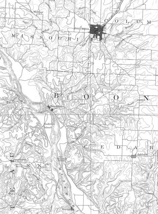
This map from 1886 shows Columbia astride the east-west Old Trails Road
This map from 1886 shows Columbia astride the east-west Old Trails Road. The Ashland Gravel toll road veered southward to Ashland and Jefferson City. Providence on the Missouri River was Columbia's port city, a place where riverboats would stop and a hotel provided lodging for the light. The final trip by stage into Columbia was over a so-called corduroy road and took a day to accomplish. A rail line completed in 1869 connected Columbia to the North Missouri (later Wabash) main rail line in Centralia. After rail delivery supplanted river shipments, Providence declined in importance and died out.
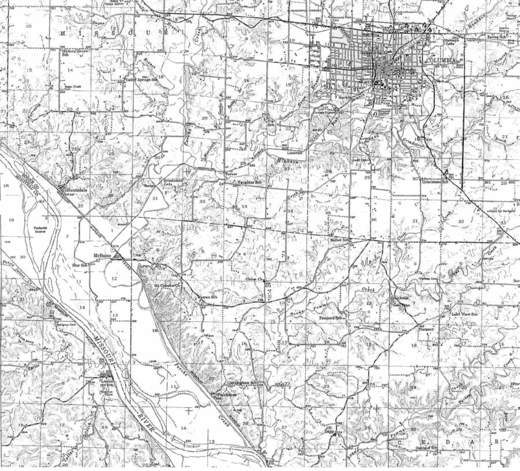
The 1948 map shows Columbia immediately after World War II
The 1948 map shows Columbia immediately after World War II. The meandering Missouri River has left Providence on Perche Creek, and the community is no longer a port. US Highway 40 was completed as a paved road in 1926 followed by the four-lane interstate upgrades that began in 1957.

404 Portland St, Ste C | Columbia, MO 65201 | 573-499-1830
© 2025 COMO Magazine. All Rights Reserved.
Website Design by COMO Marketing

Scroll To Top
Skip to content