Landscape to change with new school

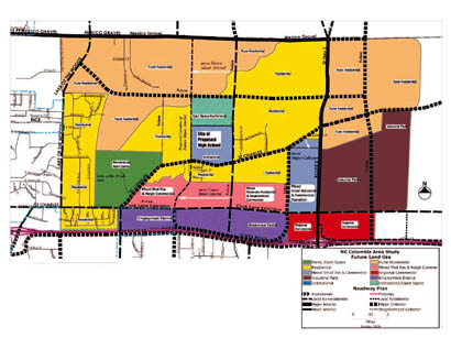
Columbia Public Schools broke ground on the new high school on July 15. To manage development around the school, the city and county created the Columbia Northeast Area Plan, which looks at five square miles around the site and recommends future land use.
Mexico Gravel Road, Route Z, Interstate 70 and Lake of the Woods Road outline the NECAP’s study area.
The school site is an old farm, and most of the land around it is agricultural. This area will get sewer access in the next year, and residential development is expected around the school, with open space planed just north of the school.
A ridge running northwest of the school will constrain this expansion, though, and that corner of the NECAP area should stay rural, along with the area’s northeast corner.
Most commercial development in the area is around I-70. ABC Labs, Fabick CAT and Loveall RVs are all along the interstate. This commercial development would intensify in the future, according to the NECAP.
The biggest changes could come along the Route Z corridor, from its intersection with St. Charles Road to the interstate exit. Along this path on the west side of Route Z is a planned commercial development that runs the length of the corridor.
On the east side of the road, about a half-mile off the interstate, there are plans and zoning in place for a new industrial park, which went on the market in April. In time, this park could look similar to Lemone Industrial Boulevard in Columbia.


